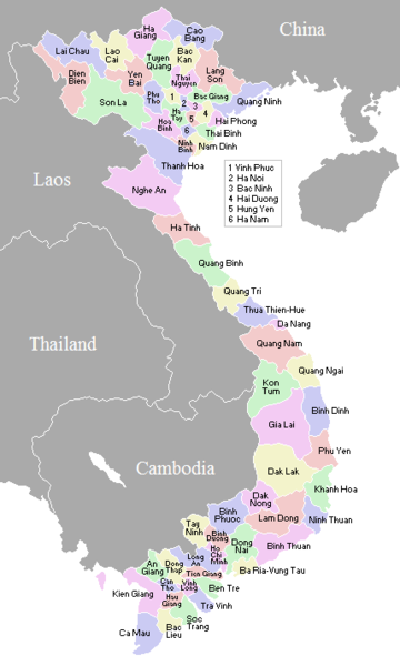
Fayl:VietnameseProvincesMap.png
Qiyofa

Bu prevyuning hajmi: 360 × 600 piksel. Boshqa oʻlchamlari: 144 × 240 piksel | 428 × 713 piksel.
Asl fayl (428 × 713 piksel, fayl hajmi: 29 KB, MIME tipi: image/png)
Fayl tarixi
Faylning biror paytdagi holatini koʻrish uchun tegishli sana/vaqtga bosingiz.
| Sana/Vaqt | Miniatura | Oʻlchamlari | Foydalanuvchi | Izoh | |
|---|---|---|---|---|---|
| joriy | 02:56, 2007-yil 2-noyabr |  | 428 × 713 (29 KB) | Vietlong | Reverted to version as of 11:41, 30 August 2006 |
| 11:47, 2006-yil 30-avgust |  | 428 × 713 (25 KB) | Vietlong | Reverted to earlier revision | |
| 11:41, 2006-yil 30-avgust |  | 428 × 713 (29 KB) | Vietlong | Correcting the boundary between Lai Chau and Lao Cai provinces | |
| 21:58, 2006-yil 20-yanvar |  | 428 × 713 (25 KB) | Vardion | correcting boundary between Dien Bien and Lai Chau provinces | |
| 05:55, 2005-yil 18-aprel |  | 428 × 713 (25 KB) | Vardion | fixing error | |
| 07:17, 2005-yil 17-mart |  | 428 × 713 (25 KB) | Waerth | {{PD}} |
Fayllarga ishoratlar
Bu faylga quyidagi sahifa bogʻlangan:
Faylning global foydalanilishi
Ushbu fayl quyidagi vikilarda ishlatilyapti:
- ace.wikipedia.org loyihasida foydalanilishi
- ar.wikipedia.org loyihasida foydalanilishi
- ba.wikipedia.org loyihasida foydalanilishi
- bg.wiktionary.org loyihasida foydalanilishi
- blk.wikipedia.org loyihasida foydalanilishi
- bn.wikipedia.org loyihasida foydalanilishi
- ca.wikipedia.org loyihasida foydalanilishi
- ce.wikipedia.org loyihasida foydalanilishi
- da.wikipedia.org loyihasida foydalanilishi
- en.wikipedia.org loyihasida foydalanilishi
- fa.wikipedia.org loyihasida foydalanilishi
- fi.wikipedia.org loyihasida foydalanilishi
- gl.wikipedia.org loyihasida foydalanilishi
- id.wikipedia.org loyihasida foydalanilishi
- it.wikipedia.org loyihasida foydalanilishi
- kk.wikipedia.org loyihasida foydalanilishi
- krc.wikipedia.org loyihasida foydalanilishi
- kv.wikipedia.org loyihasida foydalanilishi
- lt.wikipedia.org loyihasida foydalanilishi
- lv.wikipedia.org loyihasida foydalanilishi
- map-bms.wikipedia.org loyihasida foydalanilishi
- ms.wikipedia.org loyihasida foydalanilishi
- my.wikipedia.org loyihasida foydalanilishi
- nl.wikipedia.org loyihasida foydalanilishi
- no.wikipedia.org loyihasida foydalanilishi
- os.wikipedia.org loyihasida foydalanilishi
- pam.wikipedia.org loyihasida foydalanilishi
- pl.wikipedia.org loyihasida foydalanilishi
- pt.wikipedia.org loyihasida foydalanilishi
- roa-tara.wikipedia.org loyihasida foydalanilishi
- ru.wikipedia.org loyihasida foydalanilishi
- su.wikipedia.org loyihasida foydalanilishi
- sv.wikipedia.org loyihasida foydalanilishi
- tr.wikipedia.org loyihasida foydalanilishi
Ushbu faylni koʻproq global foydalanishdan koʻring.

