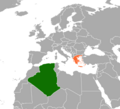
Fayl:Algeria Greece Locator.png
Qiyofa

Bu prevyuning hajmi: 659 × 600 piksel. Boshqa oʻlchamlari: 264 × 240 piksel | 527 × 480 piksel | 844 × 768 piksel | 1 160 × 1 056 piksel.
Asl fayl (1 160 × 1 056 piksel, fayl hajmi: 80 KB, MIME tipi: image/png)
Fayl tarixi
Faylning biror paytdagi holatini koʻrish uchun tegishli sana/vaqtga bosingiz.
| Sana/Vaqt | Miniatura | Oʻlchamlari | Foydalanuvchi | Izoh | |
|---|---|---|---|---|---|
| joriy | 03:52, 2020-yil 6-noyabr |  | 1 160 × 1 056 (80 KB) | Aquintero82 | Updated map |
| 21:34, 2020-yil 30-iyun |  | 1 120 × 1 040 (70 KB) | Aquintero82 | Updated map | |
| 20:59, 2011-yil 20-iyun |  | 476 × 281 (12 KB) | Reda Kerbouche | New new | |
| 20:58, 2011-yil 20-iyun |  | 265 × 144 (4 KB) | Reda Kerbouche | new design | |
| 01:35, 2009-yil 21-iyul |  | 582 × 336 (27 KB) | Aymatth2 | Highlighted Sicily, between the two countries and the main point of contact | |
| 14:59, 2009-yil 19-iyul |  | 577 × 337 (26 KB) | Aymatth2 | ||
| 14:01, 2009-yil 19-iyul |  | 798 × 628 (241 KB) | Aymatth2 | {{Information |Description={{en|1=Sketch map of Mediterranean sea showing locations of Greece and Algeria}} |Source=Own work |Author=Aymatth2 |Date=2009-07-19 |Permission= |other_versions= }} |
Fayllarga ishoratlar
Bu faylga quyidagi sahifa bogʻlangan:
Faylning global foydalanilishi
Ushbu fayl quyidagi vikilarda ishlatilyapti:
- en.wikipedia.org loyihasida foydalanilishi
- fr.wikipedia.org loyihasida foydalanilishi
- he.wikipedia.org loyihasida foydalanilishi
- ru.wikipedia.org loyihasida foydalanilishi
- tr.wikipedia.org loyihasida foydalanilishi
- www.wikidata.org loyihasida foydalanilishi
